See, Manage, Document, and Promote Your Entire Property From Above
Most campground owners work with maps, photographs, and property information collected at different times from different places. CampScan brings that information together into one current visual system.
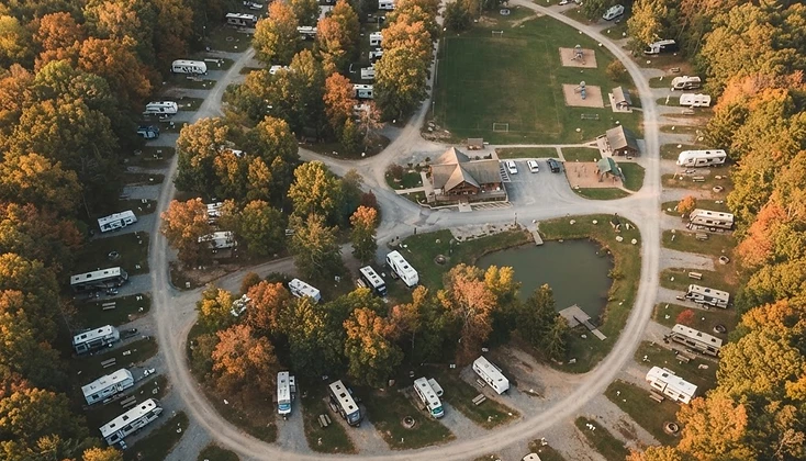
Using commercial drone imagery, ground verification, mapping, and organized visual documentation, CampScan helps campground and RV park owners understand the property as a whole — not just one area at a time.
CampScan is not simply drone photography.
Most drone companies deliver attractive pictures and video. CampScan creates practical property materials that can be used by campground management, maintenance staff, guests, marketing teams, and outside professionals.
Depending on the selected service level, one scheduled CampScan visit can produce:
- A current labeled aerial property map
- A clearer guest-navigation map
- Entrance, exit, check-in, and RV travel-route imagery
- Documentation of visible property conditions
- A numbered observation report connected to map locations
- Roof, road, drainage, vegetation, amenity, and common-area imagery
- Website and social-media photographs
- Aerial promotional video
- A visual baseline for future annual comparisons
Why a Campground Needs CampScan
Help Guests Navigate More Easily
An outdated or confusing campground map creates frustration before the guest is fully settled. CampScan creates a current visual reference showing campsite locations, roads, entrances, amenities, check-in areas, and other important destinations — reducing repeated directions, wrong turns, and confusion among arriving guests.
Better Understand Large-RV Access
Large motorhomes and travel trailers need more than an address — they need a practical route through the property. CampScan documents entrances and exits, check-in approaches, internal intersections, tight turns and apparent pinch points, turnaround areas, visible vegetation or overhead-clearance concerns, and primary management-designated RV routes.
Organize Visible Property Conditions
It is difficult to understand an entire campground from ground level. Aerial imagery can reveal patterns and relationships not obvious during an ordinary walk-through — roads and surface wear, drainage paths and washout, roof surfaces, encroaching vegetation, common buildings, directional markings, and areas to monitor over time. Observations are numbered, photographed, assigned a map location, and organized by management priority.
Create a Current Visual Property Record
A CampScan baseline documents what the property looked like on a specific date. Annual or seasonal rescans show visible changes, completed improvements, new concerns, construction progress, vegetation growth, and changing conditions — an organized visual history instead of scattered cellphone photographs.
Improve Marketing With the Same Visit
The same scheduled project can also produce professional aerial photographs, guest-map graphics, website banner images, social-media content, and promotional video. CampScan Complete combines operational documentation with marketing assets, so one coordinated visit supports several areas of the business.
The CampScan materials serve the whole operation
Management
Uses maps and property-wide imagery for planning, communication, and decision-making.
Maintenance Staff
Uses numbered observations and location-based photographs to review and organize work.
Front Office
Uses current maps and arrival information to direct guests more clearly.
Guests
Use simplified maps to find campsites, roads, amenities, and important service locations.
Marketing Team
Uses current aerial photographs, videos, and property graphics across the website and social media.
Outside Professionals
Can use the organized imagery as a starting reference when a qualified engineer, roofer, arborist, contractor, surveyor, fire official, insurer, or other specialist is needed.
Before CampScan / After CampScan
You are not hiring CampScan simply to fly a drone. You are receiving a current visual system for understanding, managing, documenting, and promoting your campground.
CampScan uses commercial drone imaging to create current campground maps, document RV access routes and visible property conditions, and produce organized marketing media. Instead of receiving only attractive aerial footage, you receive practical maps, photographs, and reports that management, maintenance staff, guests, and your marketing team can actually use.
When was the last time your campground map and property imagery were completely updated?
One CampScan visit can provide a current property map, clearer guest directions, organized maintenance imagery, and new marketing content.
CampScan provides aerial imagery, mapping, and organized visual-condition documentation. Observations are limited to visible conditions captured at the time of service. CampScan does not provide engineering, surveying, structural, arborist, fire-code, environmental, insurance, legal, ADA, or regulatory certifications. When an observation may require professional evaluation, CampScan recommends that the customer consult the appropriate qualified specialist. All flights are subject to applicable aviation rules, airspace access, weather, site conditions, privacy considerations, and the remote pilot in command's safety decision.
Start With a Clear View of Your Property
See your entire campground from a better point of view — maps, access documentation, observations, and marketing media from one coordinated visit.